Display layers
Airplane noise
Flood zones
Zoning districts


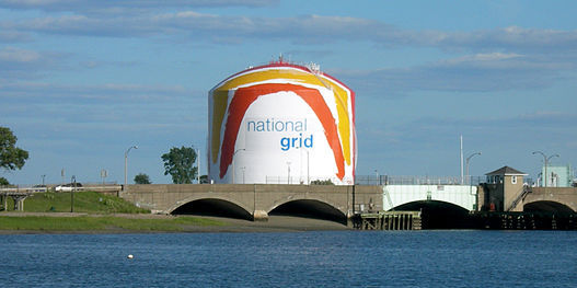
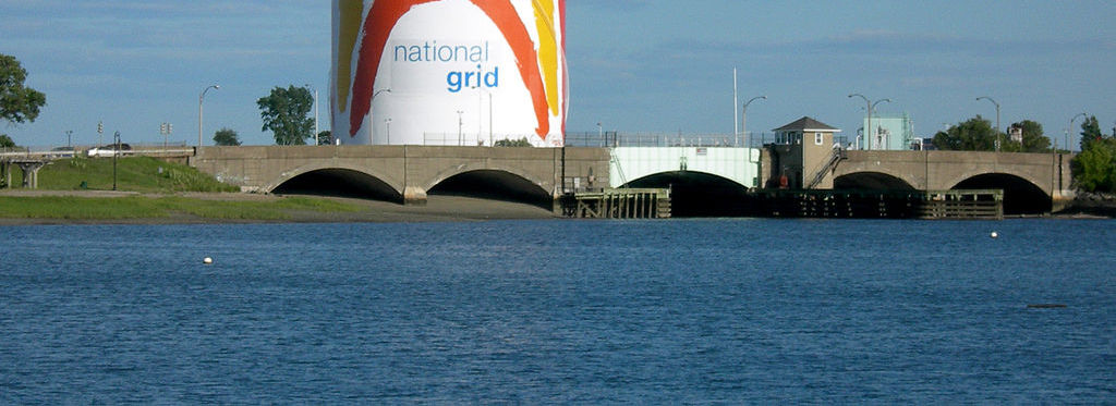
There are at least four possible sources of large-scale liquefied natural gas (LNG) fires in Boston. There are two massive LNG terminals in the greater Boston area, one at Commercial Point in Dorchester (the massive tanks with the colorful "swoosh" paintings), and the other at the Everett Marine Terminal in Everett (the largest in the United States). There is also a high-pressure LNG pipeline running through West Roxbury.
A 2004 study by Sandia Laboratory, a division of the Department of Energy, analyzed the risks of an accident or a terrorist attack on LNG shipping or storage facilities. Another study was prepared by James Fay, professor emeritus of mechanical engineering at Massachusetts Institute of Technology and a former chairman of the Massachusetts Port Authority. He cited the significant risks of having vulnerable energy infrastructure targets located near residential neighborhoods, as well as the risk posed by the LNG tankers making weekly trips through the Boston Harbor and the Mystic River area, passing near densely-developed residential areas.
• The most significant damage would be within a 1,200 foot radius of the fire. Within this area, the heat could melt steel and would cause destruction of buildings and death, according to the Associated Press and the SANE Energy Project.
• Within a two-mile radius, there would be an evacuation zone to reflect that LNG vapor clouds can travel up to two miles from their source and still catch fire if ignited.
Neighborhoods at risk from Everett terminal. The Everett terminal is the largest of its kind in the United States. The actual tanks at Everett, at equal if not greater risk of a similar breach, contain over 125 million cubic meters of LNG, ten times the amount carried in a single ship. The neighborhoods within a one-mile radius that would be vulnerable include Charlestown (especially the Medford Street/The Neck section), the eastern half of Assembly Square in Somerville, the very edge of the peninsula in the Wellington neighborhood of Medford, and much of Chelsea and Everett.
For comparison, the LNG facility at Cove Point, Maryland unloads its LNG tankers one and one-quarter mile offshore, and the facility itself sites on over 1,000 acres as a buffer from residential areas.
Neighborhoods at risk from Dorchester terminal.For the Dorchester terminal, the neighborhoods within a mile radius include: Savin Hill, most of Harbor Point, Columbia Point, Meeting House Hill, Clam Point/Harrison Square, Neponset/Port Norfolk, St. Marks Parish, the eastern half of Fields Corner, and the western half of Marina Bay in the adjacent city of Quincy.
Community opposition to high-pressure gas pipeline near quarry. The five-mile-long West Roxbury Lateral Pipeline, built by Texas-based Spectra Energy Corp., began operating in December 2016, over the opposition of residents and Boston mayor Marty Walsh. The high-pressure pipeline will carry gas at 750 pounds per square inch (psi), through residential areas including West Roxbury and Dedham. For context, regular distribution lines usually carry gas at 20-60 psi. Residents are concerned about decreased property values and the possibility of explosions, given how close the gas line runs to the blasting at the quarry, according to Northeastern University. As a result, West Roxbury is one of the neighborhoods at risk from LNG fires.